The Kedarnath Yatra is one of the most sacred journeys in India, but it has always been one of the most physically demanding. However, 2026 marks a turning point for devotees. The proposed 7km Kedarnath Tunnel project, spearheaded by the Ministry of Road Transport and Highways and the Border Roads Organisation (BRO), is set to redefine how we visit the Himalayan shrine.
In this comprehensive guide, we dive into everything you need to know about this massive infrastructure update, from the technical details of the Lincholi to Ramwara tunnel to the impact it will have on your next pilgrimage.
Read Also:- Kedarnath Master Plan 2026: New Facilities for Pilgrims
1. The Core of the Project: Connecting Chaumasi to Lincholi
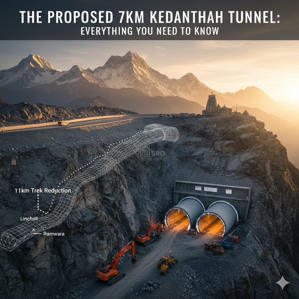
The heart of the new Kedarnath infrastructure plan is a 7km twin-tube tunnel. For decades, the journey to Kedarnath has relied on a single, often congested route starting from Sonprayag. The new project introduces a strategic shift by focusing on the Kalimath Valley.
Breaking Down the Route
The tunnel is designed to connect Chaumasi (in the Kalimath Valley near Guptkashi) directly to Lincholi or Sonprayag (depending on the specific phase of the project). By creating this subterranean passage, the government aims to bypass some of the most landslide-prone and narrow stretches of the existing National Highway 107.
Why a Twin-Tube Design?
Following lessons learned from previous Himalayan projects, such as the Silkyara tunnel incident, authorities have opted for a twin-tube configuration.
- Tube A: Primary traffic flow.
- Tube B: Dedicated emergency escape passage. This ensures that if one tube faces an obstruction—be it a mechanical breakdown or a geological shift—pilgrims have a safe, immediate exit route.
Strategic Importance
Beyond just pilgrim comfort, the BRO infrastructure updates serve a dual purpose. These roads are vital for national security, allowing for faster movement of personnel and supplies in the sensitive border regions of Uttarakhand. The project is a key component of the broader Char Dham All-Weather Road Project, which aims to keep the circuit accessible even during harsh weather.
2. The 11km Trek Reduction: A Game Changer for Pilgrims
The most exciting news for devotees is the 11km trek reduction. Historically, the trek from Gaurikund to the Kedarnath temple is approximately 16 to 18 kilometers of steep, grueling terrain. For the elderly or those with health issues, this has been a significant barrier.
How the Math Works
The new alignment significantly shifts the starting point of the foot journey. By extending motorable roads and utilizing the 7km tunnel, the effective walking distance is expected to drop to just 5 to 7 kilometers.
| Feature | Old Route (Gaurikund) | New Route (Via Tunnel/Chaumasi) |
| Total Trek Distance | ~16–18 km | ~5–7 km |
| Travel Time (Road) | 4–6 hours (due to traffic) | 1.5–2 hours |
| Trek Time | 7–10 hours | 3–4 hours |
| Risk Level | High (Landslide prone) | Low (Bypasses danger zones) |
Export to Sheets
Impact on the “Palki” and “Kandi” Services
While the reduction in distance is a boon for walkers, it also makes the journey more affordable and faster for those using palanquins (palkis) or mules. Shorter distances mean quicker turnarounds, potentially reducing the wait times at the base camps.
3. Technical Specifications & BRO Infrastructure Updates
The Border Roads Organisation (BRO) is the backbone of this project. Known for building roads at the “edge of the world,” the BRO is applying advanced “New Austrian Tunnelling Method” (NATM) principles here to handle the fragile Himalayan shale.
Key Infrastructure Data
| Project Component | Details |
| Primary Keyword | Kedarnath Tunnel Project |
| Tunnel Length | 7 Kilometers |
| Location | Chaumasi to Lincholi / Sonprayag |
| Model | Twin-Tube (Traffic + Escape) |
| Estimated Completion | 2028 (Phase-wise opening) |
| Agency | BRO & Ministry of Road Transport |
| Associated Project | 12.9 km Sonprayag-Kedarnath Ropeway |
Export to Sheets
Road Widening in Kalimath
To support the tunnel, the existing one-lane road in the Kalimath Valley is being widened to two lanes. This is crucial because, by 2030, the government expects the annual footfall at Kedarnath to reach 2.5 million pilgrims. Without these updates, the region would face a permanent traffic standstill.
4. Pros and Cons: Balancing Development and Ecology
No project in the Himalayas comes without a debate. The “Development vs. Environment” scale is particularly sensitive in the Kedarnath region, which still remembers the 2013 tragedy.
The Pros (Advantages)
- All-Weather Access: The tunnel provides a shield against the heavy rains and snow that frequently shut down the traditional route.
- Safety: Bypasses “shooting stone” zones where rocks fall onto the road during the monsoon.
- Economic Boost: Local businesses in the Kalimath and Guptkashi areas will see increased footfall.
- Emergency Response: Faster evacuation routes during natural disasters or medical emergencies.
The Cons (Challenges)
- Ecological Fragility: The Himalayas are young mountains. Heavy drilling can lead to land subsidence (sinking), as seen in Joshimath.
- Water Sources: Tunneling often disrupts underground aquifers, potentially drying up local natural springs.
- Waste Management: Increased tourism leads to more plastic and human waste in a zone that has no industrial waste processing.
5. Expert Review: What the Geologists Say
Experts in Himalayan geology offer a cautious thumbs-up, provided strict norms are followed.
“Tunnels are actually more eco-friendly than wide mountain roads,” says one senior engineering geologist. “A road requires cutting the entire face of a mountain, leading to massive deforestation and slope instability. A tunnel, if done with proper ‘controlled blasting’ and continuous geological monitoring, leaves the surface forest and slopes untouched.”
The “Silkyara” Lesson
Experts emphasize that the Kedarnath project must avoid the “shortcut” culture. This means:
- Thorough Core Drilling: Not just 3 or 4 holes, but testing every few hundred meters.
- Lining Strength: Using high-grade concrete lining immediately after excavation to prevent “squeezing” of the mountain.
- Hydrological Mapping: Ensuring that the tunnel doesn’t act as a drain for the mountain’s internal water.
6. Your Travel Guide: What to Do and What Not to Do
As the project nears its various milestones in 2026, the way you plan your Yatra needs to change.
What You Should Do
- Check Route Status: In 2026, keep an eye on whether the Chaumasi route is open for your specific travel dates.
- Register Online: The Uttarakhand government has made biometric registration mandatory. Do this at least 15 days in advance.
- Aclimatize: Even with a shorter trek, you are at 11,755 feet. Spend a night at Guptkashi or Sonprayag to adjust to the altitude.
- Use the Ropeway: If the tunnel is under construction, look into the Sonprayag ropeway (estimated to carry 1,800 people per hour) as an alternative.
What You Should NOT Do
- Avoid Illegal Treks: Do not try to use “shortcuts” or unverified trails near the construction sites.
- No Plastic: The region is struggling with waste. Carry a reusable water bottle.
- Don’t Rush: The tunnel and ropeway will make things faster, but the mountain air is thin. Moving too fast leads to Acute Mountain Sickness (AMS).
- Ignore Weather Alerts: The tunnel makes things “all-weather,” but the temple area is still open to the sky. If the IMD issues a Red Alert, stay at the base camp.
The Future of Kedarnath
The Kedarnath tunnel project isn’t just about a hole in a mountain; it’s about making a spiritual dream accessible to everyone, regardless of age or physical ability. As we look toward the completion of these BRO infrastructure updates, the goal remains clear: a safer, faster, and more sustainable pilgrimage to the feet of Lord Shiva.
Read Also:- Kedarnath Helicopter Booking 2026: New IRCTC Rules & Price List